09 June 2007

A.T. Hike, Spring 2007 - Day 5,
In Which I Joined Some Hippies

Jerry Cabin Shelter to Hogback Ridge Shelter, 14.7 miles

The first order of business today was to summit a peak called Big Butt – now there’s a mountain I can really relate to! (Who names these things, anyway!?) At 4,750 feet, it’s the highest peak of this trip. On my way, I met a pretty sizeable turtle who was sunning himself in the middle of the trail. Here he is – unfortunately he was too shy to peek out and look at my camera.

Though it was fun getting to the top of the mountain, the real reward was in pressing on to a spring four miles past, where I was finally able to take in some much-needed water. At a shelter near the spring, I ran into four hippie types – thru-hikers who were just starting their day. As I stopped to chat with them and take a brief rest, two of them rolled their own cigarettes, another lit a stick of incense, and the fourth practiced yoga. (I am not making this up!) The whole scene reminded me of a humorous book I read recently in which a sort of uptight conservative guy finds himself “living in the woods with some beatniks” for a few months. Here I was, kind of doing the same thing, feeling all Bohemian-like and almost fitting in. I totally blew my cover, though, when the hippies happened to mention that we were in a spot with a great cell signal: I took out my phone to call Jay, and my inner Bohemian got immediately upstaged by my Midwestern Pollyanna self as I started chattering. “Hi Honey! How are the kids? How was Joe’s T-ball game? Did Maria do okay at 5th-grade camp? Have you been watering my flowers?” After I put my phone away it occurred to me I must’ve come across just like Florence Brady to these four earthy hikers. Ah well.

Turns out the hippies ended up at the same place as me tonight: Hogback Ridge Shelter. I’m glad to be with people tonight, after spending several evenings solo. Also at this shelter is an older couple named Bonnie and Phil. Being from Indiana, they bring the evening’s Midwestern Pollyanna count up to three, including me. They are in their seventies and are so adorable together. They have a very meticulous routine for cooking their dinner – they brought their own homemade backpacker food which they had dehydrated themselves, and I must admit, it looked a lot better than my reconstituted black bean soup. As I chatted with Bonnie after dinner about Michigan and my family, her eyes lit up and she asked, “You didn’t happen to write an article for the ATC last month did you?” I felt like such a celebrity! She had read the article just before beginning this trip. Even the hippies fussed over me for a few minutes.

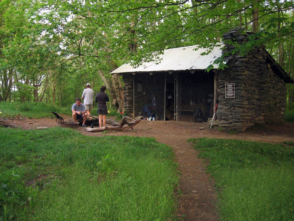
Tomorrow will be my last day on the trail. I had intended to hike for seven days, but since my plans got all bungled due to the bear problems at Walnut Mountain, I’ll end up covering all my planned miles in six days rather than seven. I don’t mind admitting that my body is completely spent and I’m absolutely giddy about finishing early.

08 June 2007

A.T. Hike, Spring 2007 - Day 4,
In Which I Did a Poor Impression of a Billygoat

Spring Mountain Shelter to Jerry Cabin Shelter, 15.4 miles

There was a very persistent mouse in my shelter last night. At one point I was lying on my stomach, looking out the front of the shelter, and the little pest ran right in front of my face, close enough that I'm quite sure I felt fur brush the tip of my nose. Due to that unnerving episode, I slept with my Petzl in my hand all night and turned it on about nine hundred times in the night to shine him out whenever he got too close.

I thought today was going to be fairly easy because in the profile on my topo map, there’s a several-mile stretch of what looks like fairly level ground. “Level” being a relative term, of course – meaning that there are certainly ascents and descents, but none of them resulting in an altitude change of more than 500 feet. What the topo map doesn’t show is that the terrain for that stretch is really not a footpath at all – it’s a series of boulders perched high atop an exposed ridge - a ridge so high and exposed, in fact, that if there is any sign of bad weather, you're supposed to instead follow a blue-blazed trail that takes you to a lower elevation beneath the tree canopy so that you don't become a lightning rod. Since the weather was perfect today, I of course opted for the ridge, not realizing at first that instead of hiking, I'd find myself “scrambling” for about two and a half hours. This is hiker vernacular for half-crawling, half-climbing like a billygoat over boulders the size of cars, your hands and feet groping wildly for any secure crevice that might keep you from cartwheeling down the side of the ridge into either Tennessee (cartwheel left) or North Carolina (cartwheel right); the trail at this point is exactly on the state line. Contributing to the drama in my case was the swinging counterweight of a 30-pound pack flopping about on my back. I was white-knuckling it the whole way during this segment, and my progress slowed to about a mile an hour. I tried to focus on the spectacular view instead of my chances of snapping a bone. Here’s what I saw to my left and to my right as I scrambled:

Finally, a grueling nine net hiking hours after starting my day, I made it to the shelter. Like last night, there is a mouse here. He made an appearance while I was eating my dinner. My biggest concern, though, is not the mouse but rather the fact that the spring near this shelter is completely dry, and I had been counting on really tanking up my water supply when I got here. I am so very thirsty, but I need to carefully conserve my water for the first six miles of my day tomorrow - first thing in the morning I have a very big climb (you know, for a change).

07 June 2007

A.T. Hike, Spring 2007 - Day 3,
In Which I Ate a Bug

Deer Park Mountain Shelter to Spring Mountain Shelter, 14.2 miles

I descended from Deer Park Mountain about 6:30 this morning and was treated to some amazing views. I love being so high up on a very clear morning like this, and looking down at those swirling clouds gathered between the mountains! Click on the photo for a close-up. Believe it or not, under those clouds is an entire town (Hot Springs, NC), and to the people down there, it looked like a cloudy, gray day until the sun burned through a few hours later.

After the descent, I followed the trail through the main drag of Hot Springs, where the trail is marked on the city sidewalk by these cool inlaid symbols. Hot Springs might seem like just a sleepy little burg to the casual onlooker, but it’s definitely a storied locale for thru-hikers – they fantasize for miles about this place, because not only is it one of the few places in the eastern U.S. where you can experience natural hot mineral springs, but the town also features an outfitter, an ice cream shop, a pub, and several little places where you can rent a room and sleep in a real bed for the night. I didn’t stick around to explore, though, because I had hours of hiking ahead of me.

After you get through town, the trail takes you alongside the French Broad River (can you beat that name!?) and then attempts to inflict a slow and painful death via a steady, steep climb up to the top of Lovers Leap Rock. If that’s not enough to do you in, there’s more: a lung-burning trek to the top of Rich Mountain. It was during that particular ascent that I inhaled a bug. Saw it coming, felt it go in. Swallowed it. Didn’t care. It was a rather businesslike decision, really, to just suck it down the old hatch and keep moving. It’s just that I was so determinedly making upward progress on that mountain, and every step was so hard-earned; it seemed like far too much energy and distraction to stop and spit the thing out. I guess now that I’m a bug eater, I could qualify for being on “Survivor” – if I looked better in a bikini.

My lawnmower blister is healing nicely, but I’m worried about another one cooking on my toe - that abnormally long toe next to my big toe on my left foot. This morning I encased the entire digit in moleskin on all sides. It still hurts though, even now that I’m stopped for the night. I’m afraid to take the moleskin off to see what’s underneath. I think I’ll just leave it be and see how it feels in the morning.

I’m alone again tonight and much too tired to worry about bears.

06 June 2007

A.T. Hike, Spring 2007 - Day 2,
In Which I Met a Loon

Roaring Fork Shelter to Deer Park Mountain Shelter, 14.7 miles

After the storm rolled in yesterday afternoon, it rained in torrents till about midnight, but today turned out to be a beauty day. Here’s a neat photo, courtesy of a very industrious spider who must’ve gotten an early start on her web when the air was still very moist last night. Click on the picture to see a closer view.

Summited Walnut Mountain and then Bluff Mountain this morning. No small feat, either of them. It’s really a pity that with many of these mountains, the vegetation is so tall and thick that even after you make it to the top of a really challenging peak, the view is usually obstructed by all the trees surrounding you. The shot below was the best vista I could snap from the top of Bluff Mountain.

I met my first loon on the trail today, and I don’t mean the wildlife variety. I was just coming down from the peak of Bluff Mountain when I noticed another hiker approaching from the opposite direction. He looked normal enough from a distance – late fifties, kind of Paul-Newman-ish. Then I noticed that everything he was carrying – his pack, his sleeping pad, everything – was made completely of Tyvek. I also noticed that he was barefoot – yes, completely without shoes or socks. (Loon or not, you gotta admit that’s pretty impressive. There were no roads or towns around for at least five and a half miles, so you know he hiked at least that far over a rocky, root-ridden trail without a stitch on his feet.) He immediately came a little too close and said a little too loudly: “Who are you?” At which point I thought, this is it. This is the end of me. This nutjob is going to kill me and cut me into little pieces with a Swiss army knife and leave my body in the woods for the bears to eat.

It was the first time I’ve felt threatened by another person on the trail. But as it turned out, he wasn’t dangerous at all, just quirky. His hike is part of a publicity effort – he’s pushing for legislation that would require all troops to go through a counseling program upon returning to the States, I guess in an attempt to stave off post-traumatic stress disorder (see his website, http://www.thelongwalkhome.org/ ). Interesting and noble concept, but he sure could use some help with his marketing plan, and some congeniality lessons wouldn't hurt either. Not to mention the fact that the barefoot/Tyvek getup had me ready to throw off my backpack and start doing Tae Bo moves in an effort to protect myself. The photo above is from his website, which I looked up after I got home.

Here’s my home for the night: Deer Park Mountain Shelter. I’m alone here and only slightly worried about bears. I did find a decent tree in which to hang my food, but I’m afraid an enterprising bear could probably have it down and eaten in mere minutes.

05 June 2007

A.T. Hike, Spring 2007 - Day 1,
In Which I Saw Two Bears

Standing Bear Farm to Roaring Fork Shelter, 15.5 miles

My hiking has begun! It was a wicked-long day and I am toast.

I started out at 7 a.m. and about an hour into the climb up Snowbird Mountain, while walking along a switchback, I suddenly heard a lot of branches breaking and something big crashing around about 40 feet to my right. See, that’s the cool thing about bears –they’re a little scary, but at least you usually have some warning that they’re around because they’re big enough and clumsy enough that they make a lot of noise. Anyway, through the trees I saw this ball of black fur, maybe a 100-pounder, and I had apparently scared him because he made quick work of loping away from me. I watched him till I couldn’t see him any more; then I started to move on, thinking smugly, “How fun, I saw a bear my first day, and look at me – such a seasoned hiker that my heart’s not even racing.”

Then a second bear darted right in front of me, maybe 30 feet ahead, and bumbled his way up the mountain. That’s when I nearly fell over backward and my heart rate doubled. See, both bears were juveniles, which meant their mother was probably close by, and here I was, between her two darlings. Probably not the safest place to be. I quickened my pace and was all nerved up for about an hour, until I had gotten well out of whatever feeding territory of theirs I had apparently invaded.


I noticed lots of evidence of wild hogs on the trail today. There are many areas where hundreds and hundreds of Mayapples (these grow in Michigan too and look like the one in this photo) have been rooted up and scattered about, and many upturned areas of soil where the hogs have looked for truffles. I’m guessing the weather has caused a food shortage for them as well as for the bears.


Below is a view from the summit of Max Patch, which was one of the coolest sights today – I’d heard a lot about it. It’s a bald, about 4,600 ft. in elevation, and it used to be the site of an old logging camp. It’s very pretty at the top but a storm was collecting in the distance so I didn’t linger too long there. The rain started about 4 p.m. so the last half-mile of my hike was wet.

At tonight’s shelter I met two young guys who are thru-hiking at the rate of 25 miles per day (hot doggers!) and they offered to hang my food bag with theirs, to which I readily agreed. Chivalry does come in handy at times.

No blisters yet, unless you count the one on my thumb which, actually, I brought with me. I produced it while pushing the lawn mower on the day before I left. Now that’s an outdoorswoman for you – I get a blister while lawnmowing. It broke open and had started to heal by the time I hit the trail. Today it resembles a small piece of prosciutto.

I drank more than six liters of water today.

04 June 2007

A.T. Hike, Spring 2007 - Day 0,
In Which I Scrap My Carefully Planned Itinerary

I’m at Standing Bear Farm, the hiker hostel just off the A.T. (same place where Cindy and I stayed for a night last year) and will get on the trail early tomorrow morning. The Steve Miller Band and I enjoyed a great drive down to Tennessee; James Taylor and Norah Jones joined in for about a hundred miles too. Thank goodness for the iPod or else I’d most certainly go catatonic being cooped up in the car by myself for so long.

Unfortunately, I found out from a few other hikers here at the hostel that in the last couple days there’s been a lot of aggressive bear activity at Walnut Mountain Shelter, which is (rather, was) my destination two nights from now. Apparently the other night a bear absconded with eleven hikers’ food bags. He also played piƱata with what he thought was one giant food bag – but which was actually a hiker sleeping in a hammock just outside the shelter. Oy. I’m told the bears are very hungry right now because, due to a late cold snap and a recent drought, a lot of the berries they rely on for food did not produce very well this spring.

Anyway, hikers are being advised to stay away from that shelter for now, especially when hiking alone. This presents a problem for me, because skipping that shelter means more than doubling my planned mileage tomorrow. I had kind of looked forward to easing into my hike with a nice easy 7.5- mile day. Now it looks like it will be 15.5 miles. Crud.

26 May 2007

A.T. Journeys Article

A.T. Journeys, which is the magazine of the Appalachian Trail Conservancy, published a little thing I wrote about my hiking odyssey. You can read the full text of it here.

It's my first non-work-related stuff to ever get published. So who woulda thunk I'd have writer's remorse about that?! But now that it's actually in print and has been mailed to 40,000 people, so much of it sounds so... goofy. But it felt inspired at the time that I wrote it, so there you go.

08 April 2007

South Rim of the Grand Canyon


While indulging in a long weekend in Las Vegas during spring break, Janet and I spent an amazing few hours at Grand Canyon National Park. When we signed up for this "luxury motor coach tour," I had no idea that it involved a wicked-long 4.5-hour bus ride. But I must say, despite the very bad food they served us and the really annoying humor of the bus driver, it was totally worth it. The Grand Canyon is astounding. Breathtaking. Enormous. Majestic. Actually none of those words even begin to describe it. It's like nothing I've ever seen. I need to go back there some day and backpack the switchback trail down to the canyon floor.

So. The bus drops us off at the south rim and gives us some time (not nearly enough) to hike around. First thing we see is a lovely little lookout point — crammed, of course, with hordes of sunburned, camera-toting tourists, because it's the closest viewing area to the parking lot. We shuffle through the crowd, waiting our turn to look over the edge. When we make it up to the front, we're gazing out at the canyon from the safety of the lookout point — which, by the way, features a comforting, solid metal railing all the way around the edge — and Janet spies a distant, unguarded precipice much further down the trail. In a serious, determined tone, she says, "We're going over there."

As she starts hoofing it down the trail, I follow her line of vision to the gigantic column of rock about a quarter-mile away. It's a peninsular cliff that is alarmingly narrow at the top, forming a teeny-tiny little flat part — what I would call a mere sliver of a rock table, actually. There is absolutely no railing around any of it, and there are 5,000-foot dropoffs on all three sides. This is not a place you'd find those little binocular viewers on metal stands that give you a close-up of the vista for 25 cents. "Uh... I don't know... do you think they really let people climb out there...?" I call weakly after her, wincing. "I mean, it doesn't really look like an official lookout..." But she's already twenty paces ahead of me, chirping merrily, "Hey, it can't be worse than when when we hiked to the top of Angel's Landing!" Before I have a chance to reason with her, I'm scrambling after her over the rocky trail, trying to catch up while glancing longingly back at the guard rail.

Ten minutes later, I'm at what feels like the edge of the earth. I'm pretty sure I've blocked out most of what it took to get there, but I vaguely recall crawling in a rather undignified manner on all fours for some distance, until reaching Janet at the point where the photo above was snapped. What this shot doesn't reveal (thankfully) is that my heart is racing at about 250 beats per minute and I'm about to hyperventilate. And believe me, there's a reason why I'm crouching — I was pretty sure that if I stood fully up, a swift gust would sweep me neatly over the edge, affording me what some call "the one-minute Grand Canyon tour." And that would be the end of me.


This next shot, though it looks nearly as scary as the one above, was actually much less death-defying. See, just off to my right (but out of the view of the camera) is a large, flat, secure space that I could easily throw myself onto should I feel a surge of vertigo coming on. Trust me, I wouldn't have hesitated to do it.

By the time we made our way back to the real trail — I mean the one that normal people walk on — I was so hopped up on adrenaline that I felt like I had just run a 10k. Can I count that as a workout, I wonder?

18 March 2007

Potawatami in the Spring

Great hike today! Pete and Cindy had the kiddos overnight, so Jay and I took advantage of the time by getting out on the Poto for most of the day. It was a little blustery and there was still some snow on the ground here and there. We didn't do the whole 18 miles, but we did accomplish a pretty respectable 12-mile loop. It was a good breaking-in of two important items: (1) Buster's new backpack and (2) my new Merrell trail shoes.

We procured the doggie backpack because the dingo's going to need to schlep his own food and water this summer when we hike through the Porcupine Mountains. Today was a good test for that. He was kind enough to carry our lunch on one side of his pack, and a water bottle on the other. Total payload: about three pounds. Good boy. He made it through our 12-mile day just fine, which tells me that our hikes in the Porkies (which will probably be shorter than 12 miles) will be a cakewalk for him.

The Merrells, well, they did just okay. This is a new adventure in footwear for me... I am moving away from my heavy, leather, Vibram-soled Salomon hiking boots, and attempting to go ultralight with these featherweight hiking shoes. I've had the shoes for a couple months but today was the first time I'd worn them for any kind of distance. I'm still slightly concerned about what they're doing to the back of my right heel. They didn't produce any blisters today, but there was definitely a hotspot back there by the time we were done. I'm banking on my baby-thin heel skin toughening up a bit between now and June.

16 March 2007

Seen on patagonia.com

I'm setting my sights on my next AT segment. In June I'll do another 80 miles or so on the Tennessee/North Carolina border. As I was perusing the superhighway of backpacking equipment available online, I found the following quote on the Patagonia website. What a perfect statement of why I love backpacking.

"We enjoy silent, human-powered sports done in nature, where the reward involves no audience and no prize other than hard-won grace. These entail risk, require soul and invite reflection. They bring us closer to the natural world and to ourselves."


08 September 2006

Joe's First Backpacking Trip

Joe's been wanting for a while now to try out backpacking, and this weekend we finally made time to get that boy on the trail. This being his first time, the theme of our adventure was "easy and fun." Maria (who, after backpacking the Nordhouse Dunes trail along Lake Michigan a couple of years ago, considers herself quite an expert hiker) helped me map out a short overnighter on the Potowatami, with our destination being the campsite at the edge of Blind Lake. It was just the three of us, since Jay was up north backpacking the Porcupine Mountains with some buddies.

We parked at Mark and Diane's house and picked up the trail near the bridge at the end of Crescent Drive. It was less than two miles to the campsite, but there's a significant climb right at the beginning of this hike, and a significant drop near the end. Made it feel like we were working some, so that's good. Joe had a great time, even though we outfitted him with some very makeshift equipment. Looks like it's time to log onto the REI website and start procuring that boy some gear!


The lure of roasted marshmallows definitely increased everyone's interest level in taking this trip! And it was perfect that the Blind Lake campsite has this awesome firepit where you can make a nice little campfire without too much trouble. We even scored a burning log from an empty neighboring campsite, which made it really easy to get some flames going. Someone had apparently had a fire there the night before and we noticed there were still some smoldering logs in it. (We won't mention that the children nearly witnessed their mother burn half her hand off, trying to procure the firewood from the other campsite and drag it over to ours.)
Mark and Diane boated over after dinner time to check on us and hang out for a little while. Uncle Mark entertained a wide-eyed Joe with all sorts of stories about wildebeests that live in these forests (thank you, Mark) while Maria discussed Harry Potter with Aunt Diane. They headed home a little before dark and the three of us plus Buster got settled into our tent.
This was Buster's first backpacking trip too. He did okay until about 9 p.m., when someone across the lake started setting off fireworks. Buster has this phobia about any loud noises that resemble thunder. They turn him into a drooling, trembling mess, and in this particular instance, also produced a bad case of flatulence. (It didn't help that, a couple hours earlier, Buster had sneaked off with a large bag of our yogurt raisins and consumed them all before we realized they and he were missing.) If our tent hadn't been staked down, that baby would've gone up like the Hindenburg. Jay continues to express his gratefulness that he happened to miss this particular trip.

Overall, though, this adventure was a big success. I can't wait to give the kids a more substantial backpacpking experience. It's definitely on our list for next summer!

02 August 2006

Lower Tahquamenon Falls

Remember my grandiose idea of taking the kids on a big hike at least once a week this summer? Well, my nicely laid plans got foiled by Joe's broken tibia. At the end of April he had a wipeout on his bike which landed us at Chelsea Hospital for several hours and resulted in my boy lying immobile on the couch for eight straight days. Not exactly conducive to hiking. Once his leg was in a cast, over the next seven weeks he progressed from the couch to a walker, and then to crutches. It was nearly the end of June before his cast came off and he was able to amble around without restrictions — gingerly at first, but quickly ramping up to his usual whirling-dervish pace. And let me tell you, he was good and ready to make up for seven weeks of lost time.

It was the perfect time to head north.

We had planned this trip earlier in the year and were thankful that it coincided nicely with Joe's leg healing. Two days after the cast came off, we drove up to Mackinaw City and set up our home base there at a little beachside cabin, from which we could see both the Mackinac Bridge and Mackinac Island. After spending a day and a half swimming and frolicking, we slipped into our Tevas and headed even further north for a day trip to Tahquamenon Falls.

After we crossed the Big Mac (which, incidentally, is the world's longest suspension bridge), the drive was peaceful and remote in that Upper-Peninsula kind of way. We spent a good hour traveling down a two-laner lined with righteous-looking forests on either side, seeing only a handful of other motorists going to or fro. Except for the forests, the two biggest attractions during the drive were (1) a dead porcupine on the side of the road (yes, we did stop to gawk; you will thank me that there are no pictures), and (2) a town called Paradise (quite paradoxically named, by the way) which boasts an ice cream shop called, cleverly, the Troll Trap. Don't worry if you don't get the joke — it's kind of a Michigan thing.

When we got to the park, the four of us plus the hound got in a boat and rowed across the Tahquamenon River to a little island in the middle of the lower falls. There we found a winding path to the falls and set about the serious business of exploring.

It was a lot like what we experienced when we hiked the Virgin River in Utah — the best part being that you can get right in the water and wade for miles! Once you pass the first and biggest cascade (shown below — click on the picture to get some perspective of its size) at a large observation deck, the remaining drops in the lower falls are very small, gentle, and inviting. In fact it's not too crazy of a thought to actually hike all the way up the river and get a good view of the much larger and grandiose upper falls. For a fleeting and ambitious moment we thought we might do just that. After all, most spots in the river between upper and lower are only about six or eight inches deep — plenty manageable for even the shortest-legged member of our party (Buster). But the distance to the upper falls is eight miles, and considering we covered only about two miles in a little over an hour, we decided to head back.

This is a great hike for kids, because what's not to like about getting into a rowboat, rowing to an island, and splashing around a bit in some waterfalls? We would go back again in a heartbeat. Even if we didn't get to see a dead porcupine.

03 June 2006

Cosby Knob Shelter to Standing Bear Farm

Appalachian Trail, 10.4 miles

It rained all night, but at least the rain noise covered up the cacophony of snoring from all those men. We were up, fed, packed, and hiking out a little before 7, a new record for us. It wasn't a moment too soon. That was probably the most unpleasant shelter experience I've ever had. I will confess to taking a little bit of guilty pleasure in making a small ruckus this morning as we packed up. I didn't feel at all bad that we might be disturbing the sleep of the steak-eating snorers. Way I saw it, it was paybacks for the previous 10 hours.

By 8 it started clearing up and turned into a really beautiful day -- a great way to end a great week. The sun streaming in through the trees was such a beautiful sight. It felt and looked like we were walking through a rainforest, only without the muggy heat.

Summitting Mt. Cammerer this morning was a little bittersweet, as it was the last big climb we'd experience in Great Smoky Mountain National Park. Here's a really great view from the side of that mountain -- aren't those clouds amazing?


We took the remaining downhill miles pretty quickly, enjoying the mountain laurel blooming along the way, and lunching at Davenport Gap Shelter. After that it was only one more mile till we finished the park, and four miles to our car. Here we are at Davenport Gap, which is the end of the GSMNP section of the AT:

Of the remaining few miles, about two of them followed an amazing riverside trail along the Pigeon River.

The big surprise of the day was that we had another climb to get back to Standing Bear Farm -- I hadn't really planned on that! My topo map only took us through Great Smoky Mountain National Park, and all I knew was that Standing Bear was three miles past the park border. Who knew it was uphill!? But we took it on the chin and muscled through to the end. It sure was a beautiful sight when we finally came to the intersection of the AT and Waterville School Road...
...and an even more beautiful sight when Cindy's Trailblazer came into view. We are now on our way to a hot shower, a huge dinner, and real beds with real sheets and real pillows.

02 June 2006

Tricorner Knob Shelter to Cosby Knob Shelter

Appalachian Trail, 7.7 miles

It was very cold here last night; I slept in two pairs of pants, my fleece, and my raincoat. I could see my breath this morning. The journal inside the shelter indicated that there had been two feet of snow here just a couple weeks ago. I've read that this is the coldest area of Great Smoky Mountain National Park. Mt. Guyot, which we summitted this morning, is only 20 feet lower than Clingmans Dome, but because of its position, it gets more exposure to extreme weather.

The bruised part of my arm is killing me. It is turning all different shades of purple and black. Nice.

I was thankful for a short mileage day today, especially because it rained a lot again throughout the day. We hiked through some beautiful wild rhododendron thickets on the way to Cosby Knob. We arrived at the shelter around lunchtime and I enjoyed a delicious two-hour nap plus ample time to read and relax. My feet appreciated the break.

And thank goodness we got here early enough to stake out a little corner of the shelter, because it is Friday night, and a slew of weekend-warrior type men showed up about 5 p.m. after hiking in from Davenport Gap. They actually brought with them a huge hunk of steak and cooked it in the shelter since it was raining cats and dogs outside. The sight of someone pulling raw meat out of a stinky backpack and then cooking it up about four feet from my head was enough to turn my stomach. And I couldn't quit thinking about how these men had just infused the entire shelter with enough food odors to attract probably every bear north of Clingmans Dome.

It kept raining all evening, and more hikers kept coming, some of them thru-hikers who were wrapping up a 20-mile day. You can't really say "oh sorry, there's really no more room" when the rain is coming down in torrents, so we just kept squeezing in. All told, I believe we currently have 18 people crammed into a shelter that is supposed to accommodate 12. It is quite uncomfortable. We're going to blow out of here as early as possible tomorrow morning.

01 June 2006

Icewater Springs Shelter to Tricorner Knob Shelter


Appalachian Trail, 12.6 miles

The sunrise this morning at Icewater Springs was lovely. Though the highest peak of our trip was yesterday, we are still really high up. There is a strong scent of pine in this altitude because more conifers seem to grow at the higher elevations. It's a wonderful smell.

And speaking of smell, I'm happy to say that hygiene is on the upswing. Last night just before going to bed, I sponged the grime and sweat off my body and switched into my second set of hiking clothes. Typically, for a one-week trip, you bring only two sets of hiking clothes: one to wear for the first three or four days, and one to wear for the second three or four days. Yes, I did write that correctly: you wear the same clothes for days. You can imagine how close to the earth you feel (and smell) after hiking and sweating in the same garments for that long. But extra clothing equals extra weight, and there's no room for frivolous ounces in an already heavy pack. Princess that I am, I also bring my "black ensemble" for changing into at the end of each day: a lightweight black long-sleeved capilene shirt and long-john pants. These offer dryness and warmth -- which is important because hypothermia can happen even in spring and summer if you get caught in rain and your body temperature dips too low.

Also on the topic of clothing: this time I brought with me a homemade hiking kilt that I made out of ripstop quick-dry nylon. Kilts are all the rage among female and male hikers these days. In fact, just yesterday we saw a guy wearing a kilt on the trail. Mine's not working out though. It's comfortable and all, but it's too long to stay clean -- it drags in the wet grass and gets caught on stuff. Any shorter, though, and I'd feel like it offers too much potential for flashing other hikers. So I won't bring it again. For this trip, I'm putting it to use as a pillowcase by wrapping it around my frontpack, which doubles as a pillow.

Today's highlight was Charlie's Bunion. (You gotta love a mountain that's named after a foot deformity! Especially after spending the last several days abusing our feet with all this climbing!) Getting to the top reminded me of hiking Angel's Landing in Utah a couple years ago. It was pretty breathtaking. The photo of Cindy and I was taken at the top. It's hard to appreciate how high up we were; I wish I would've photographed this spot from a few different angles.

Here's that hazy view that the Smokies are famous for. This was taken from the top of Charlie's Bunion.

And here's a great view I snapped about a mile later, showing the backside of Charlie's Bunion.

This afternoon it started to rain pretty intensely and we got soaked on the way to Tricorner Knob. I still don't have any blisters, but I'm feeling a lot of hotspots from all the friction produced by wet feet sloshing inside of wet boots. My feet were absolutely pruney by the time I took my boots off at the shelter tonight. I'm sad to say, I think I need to lay these boots to rest when I get home. They've lived a long and happy life, but they're really starting to fall apart.

I slipped on a wet log this afternoon and I went down really hard. I cut my leg and hand, and I'm afraid I really injured the back of my arm. You know that spot where I should have a sinewy little tricep but which is actually pretty soft and fleshy? Well, when I fell it got slammed (badly) between a rock and my pack. I think I'm going to have a gigantic bruise there; it's quite sore. I'm lucky I didn't break anything, especially since our location at the moment is considered to be the most remote shelter area in the park. Actually, pretty much everyplace in this park feels remote and wild. Unlike previous sections of the AT, there are very few places where you feel at all close to civilization. In the entire stretch of Great Smoky Mountain National Park, the AT only crosses a road twice, and both of those times were yesterday. Once at Clingmans Dome and the other at Newfound Gap. As Dan the Bear Man put it, "You should try not to get hurt; it takes a long time to get help. Sometimes we have to carry dead people out of here."

Speaking of Newfound Gap, it felt so weird to emerge from the wild and see a parking lot, a rest area, sidewalks, and people! We felt like a freak show. We were covered with dead bugs, grime, and sweat. We drew curious looks from more than a few tourists. It felt good to get back into the woods.

31 May 2006

Double Spring Gap Shelter to Icewater Springs Shelter

Appalachian Trail, 13.8 miles

It wasn't exactly great timing, the fact that our longest hiking day came on the heels of our night with the bear. We had gotten maybe half the sleep that we normally would've. But our itinerary had no wiggle room, so we were up and out at dawn this morning, our first hurdle being Clingmans Dome, the highest point on the entire Appalachian Trail. In this photo, we're about a quarter of a mile from the summit, and I'm trying to negotiate a steep and rocky part of the ascent.

For breakfast, in addition to my usual protein bar, I had my most prized menu item: a cup of applesauce. It was a good day to carb-load, since the climb ahead was hard. Plus, better to consume the heaviest item in my food bag on a hard day than to carry it!

The trees at this elevation show a lot of signs of the harsh elements. A lot of them look like this stick of a pine tree -- ravaged by extreme heat in summer and extreme cold and wind in winter.

We summitted Clingmans Dome at 8:45 a.m. and it was such a rush. It really redeemed the disappointment I had felt over our previous AT trip fizzling. The morning was clear and beautiful, and there was not a soul at the observation tower. I was really glad for a moment of peace up there, because sometimes that tower can get really clogged with tourists. This is one of the few points in the park where the trail intersects with civilization. An access road allows tourists to drive within half a mile of the summit, and then they can walk a paved path all the way to the top.

At the top of the observation tower I finally got a strong enough signal to phone home, though it took several attempts. It was so sweet to hear Jay's voice. No matter that he was in the middle of an interview at work and, once off the phone, probably had to explain to the poor interviewee what a kook he has for a wife! We couldn't talk long, but long enough for me to find out that Joe's little virus had run its course and that he and Maria were doing fine. I miss those three terribly.

We are at Icewater Springs now, with several other hikers, having made it through the longest day of our hike. All of us had to hike the last couple miles (which were very rugged) in the rain. I am filthy and sweaty. Everyone stinks but no one really cares. It's remarkable the way you lose your sense of decorum out here. Case in point: Tonight there were several lengths of rope strung across the shelter, with everyone's stinky, sweaty underwear and socks hanging from them. Mine were right up there along with everyone else's.

Night of the Living Bear

I'm including the following events as a separate entry because the hours between nightfall on May 30 and the earliest part of May 31 turned into such an adventure that it felt like a whole separate day!

After dinner, Dan the Bear Man set up the bear snare behind the shelter. The snare consists of a clamp and a metal cable secured to a tree, all hidden with branches and baited with a can of tuna. Bear Man explained that bears love tuna, but that he sometimes uses bacon because bears are really attracted to that too. (As he was saying this, I realized with horror that my food bag contains several foil packets of tuna and a large shrink-wrapped package of pre-cooked bacon. Note to self: consider bringing some other forms of protein next time.)

The idea is, when the bear goes for the bait, the snare clamps his leg and restrains him long enough to be darted with a sedative. The drug makes him limp but still somewhat conscious. While in this compromised state, the bear gets tagged and measured. Since bears hate to be vulnerable and manhandled, the whole experience is hopefully so negative that the bear stays away from the area where all this occurs. However, if the bear does choose to keep coming back and posing a threat to hikers, the Park Service's only other option is to drug him again, and then physically relocate him to another part of the park! Picture four Park Service guys carrying a comatose bear on a stretcher, up and over miles of mountains. This really happens sometimes!

After the buildup of watching the snare being built and participating in all this bear talk, I was pretty nerved up. And all we had left to do all evening was sit around and wait for nightfall. I tried to read a book I had brought with me, but I found myself just sitting there staring at the (now flimsy-looking) chain link fence on our shelter, wondering what kind of force it could withstand. While we sat around, Bear Man passed around his night-vision goggles for us to look at. The goggles lent an eerie green cast to everything, but they really did provide amazing ability to see in the dark. It was especially cool to look up at the clear night sky and see zillions more stars than our normally feeble eyes are capable of noticing.

About dusk, two more Park Service guys showed up for the stakeout. They too would be spending the night at the shelter, to help with the bear. This was turning into quite a large-scale sting operation. All of us -- three Bear Men and six hikers -- burrowed into our sleeping bags about 9 p.m., wondering what the next few hours would bring. We heard coyotes howling as we were lying there trying to go to sleep.

I dozed until 11 p.m., when I suddenly heard Bear Man #2 frantically whispering: "DAN! DAN! DAN!" Apparently he had heard the snare activate. Dan and the other two Bear Men immediately jumped out of their sleeping bags and into their boots, and went trotting out back. All six hikers (including me) followed suit, headlamps beaming, to see a 350-pound black bear thrashing around in the snare and doing the best voice impression of Chewbacca that you've ever heard. They shot him with a dart full of sedative and he quieted down... for a moment. Then he started thrashing and yowling again. Another dart. Another brief moment of quiet. More thrashing. This cycle went on and on till they had used up seven darts -- the amount that would normally be used on a six hundred pound animal! None of the three Bear Men could figure out how the bear could stay that worked up with all that sedative in its system. They (and we) were relieved when he finally lay down and his breathing slowed a bit.


While the bear was sedated, we got to photograph him and touch him. His fur was very soft, like a dog, only longer.
Then the three Park Service guys went to work cooling him down. He had gotten so agitated during the sedation ordeal that his body temperature was quite high, and Bear Man was worried that this might result in a seizure. So we brought our water bottles and they started dumping cold water on his fur until he cooled off a bit. (For the record, the water bottle in this picture is the same one I drank out of during this trip!) Once his temperature was under control, the next task was to tag the bear's ear and take a whole bunch of measurements for the Park Service records. That's about the time I finally went to bed. It was a little past 1 a.m.

Once the sedative started wearing off and the bear came to, Bear Man and his friends basically ran him off, and he was glad to get the heck out of there. By then it was after 2:30 a.m. As far as we know, he didn't come back that night.

30 May 2006

Derrick Knob Shelter to Double Spring Gap Shelter

Appalachian Trail, 7.2 miles

A much shorter day today mileage-wise, but it stretched into a nearly 6-1/2 hour trek because of rain. It was beautiful all morning, but just as we stopped for a quick break at Silers Bald Shelter, a substantial storm blew in, so we ended up staying there for like two hours. It kind of put the brakes on a pretty well-paced day, but oh well. We were thankful that we didn't get soaked. We waited till the worst of the rain was over, then pushed on through our last two miles to Double Spring Gap while it was still sprinkling.

I had feral pigs on my mind today because of the two other hikers' boar sightings yesterday. Those animals scare me, probably even more than bears. They're reputed to be very unpredictable. We saw lots of cloven-hoof footprints in the mud today, and big patches where the pigs had rooted up dirt and leaves, looking for food. I worried about running into hogzilla every time there was a bend in the trail. A ranger told us that the pigs are a terrible nuisance because they're an invasive, non-native species with no natural predators, and they compete for food with the bears and the deer. They also eat all kinds of rare and endangered plants, including wildflowers and beech saplings. Apparently the pigs were introduced to this area accidentally when a handful of them escaped from a game preserve in Georgia several decades ago. They multiplied like rabbits and now they're all over the Smokies. The Park Service kills as many of them as they can, in an attempt at pig population control.

This morning I was running dangerously low on TP. I realized after we hit the trail that I only packed half the tissue that I intended! Crisis was averted, however, when I put on my rain parka this afternoon and found an entire package of Kleenex in the pocket. Woot! Must've left it there last weekend when we hiked the Poto.

Still no blisters, despite hiking through wet weeds and mud puddles this afternoon. My boots seem to be leaking quite prolifically, though, which does make for some discomfort. I don't think Gore-Tex boot linings are all they're cracked up to be.

We have been trying frequently to phone Jay and Pete, but still cannot get a signal. We had hoped we might get cell reception at the top of Silers Bald (here is Cindy at the top, cell phone in hand!) but it didn't work.

The shelter where we're staying tonight is one of the few in the park that still has a chain-link fence across the front. At one time, all the shelters in the park had this feature, with the intent of protecting hikers from bears at night. But the fences apparently made people feel a little too safe, because many started keeping their food bags with them overnight in the shelters instead of hanging them from the bear cables provided nearby. (Duh!) Then, in a really remarkable lapse of common sense, some began actually feeding bears through the shelter fence! All this, of course, compounded the bears' interest in hanging out at shelters. They learned to come around at dusk for their nightly feedings, and they started getting surly when hikers didn't pony up their goodies.

After a while of battling the bear problem, the Park Service decided to try removing the fences from just a couple of shelters. Hikers who visited those shelters obviously felt a stronger sense of responsibility for their own welfare, took care of their food properly as a result, and the bear problems at those shelters stopped. Now the Park Service has removed most of the fences.

I'm glad, however, that tonight's shelter still has a fence. Because when we arrived this afternoon, we were greeted by a Park Service guy named Dan, who has a gun, a snare, and night vision goggles. Dan's main job is to hunt and kill the wild pigs that live in the park. But tonight, he is Dan the Bear Man. He's here to corner and sedate a bear who has been frequenting this shelter and causing problems. It might be an eventful evening.

Four other hikers are here tonight.

Here are Cindy and I, nervously awaiting nightfall in front of our shelter, and wondering if the bear will show up.