06 November 2004


On the Poto: Cindy, Janet, me, Pete, Nathan.

Another Day on the Poto

Potowatami Trail, 17.5 miles

Did the same route as on 25 September, this time with Janet, Cindy, Jay, Pete, and Nathan. It was a perfect hiking day -- clear and sunny, mid-fifties. Was really proud of Nathan -- it's a very long way for a 13-year-old! He and Pete took a shortcut near the end that shaved off about three miles, but still -- Nate was definitely the hero of the day. Janet made him a Boston cooler when we got home, and I made him a huge pot of rice!

Since traveling in a group slows you down, it took us 5:48 (net hike time) to complete the trail. It was starting to get dark by the time we finished. Maybe Jay and I will do this hike again in the winter or spring. I wouldn't mind making this an annual thing...

15 October 2004

Tray Mountain Shelter to Dicks Creek Gap

Appalachian Trail, 10.6 miles

Last day of this section hike -- bittersweet. Started out very early in bitter cold and wind. I am so happy it did not rain -- I think I would've died of hypothermia! Had to conquer a few moderate ups and downs, then huge, hard peak called Kelly Knob. Whoa. It was a big challenge. It was such a blessing to finally arrive at Dicks Creek Gap and see my car! I feel so proud of myself for completing such an aggressive, challenging hike.

Things I learned on this hike:
  • If there's a possibility the temperature will be in the fifties or lower, bring gloves, earband, and long underwear. I can't believe how cold I felt. I thought this was the south.
  • Bring a tea light for each night you plan to sleep in a shelter -- it seems to keep away mice and adds very little weight to your pack. Carl and Mike did this and it was nice to have constant light without worrying about flashlight battery life.
  • If possible, dunk your feet in a cold stream at the end of the day to ease fatigue and tame blisters. For all the jawing Louie did, this was one helpful tidbit that made it worth listening to him for three days.
  • Don't bring natural peanut butter or almond butter in plastic bags. The oil penetrates the bags and gets everything all oily. Eeew.

14 October 2004


For a brief moment, the rain cleared and I snapped this picture from the trail.

Low Gap Shelter to Tray Mountain Shelter

Appalachian Trail, 14.9 miles

Oh my word, what a hard day. Started in the rain and aggravated my blisters all day with wet socks and wet shoes. Even worse, it was a three-mountain day: Blue Mountain, Rocky Mountain, and (finally!) Tray Mountain. This day definitely felt like passing through the fire. I was so proud of myself for finishing.

By the time I got to the shelter the rain had stopped -- I was so thankful. Keith showed up later that afternoon. I was glad of this, because everyone else -- Louie, Carl, and Mike -- was done with their hike and had stopped at Unicoi Gap. It would've been spooky staying at the Tray Mountain shelter alone. It got very cold and really, really windy at night. I wore my gloves, earband, long underwear, pants, shirt, fleece, and raincoat to bed -- in my twenty-degree sleeping bag! -- and I was still cold. It rained much of the night and I worried about how I could stay warm and dry the next day.

13 October 2004

Blood Mountain Shelter to Low Gap Shelter

Appalachian Trail, 13.0 miles

Today I got up and started early because I was anxious to get to Neels Gap, two and a half miles down the mountain. There, I picked up mail from Jay and the kids, Janet, Eva, and a few others -- it made me cry and I miss everyone terribly. I don't know where my head was when I thought I could backpack alone for an entire month, let alone the week that I am undertaking right now.

It drizzled all day and started getting cold. I was the first at the shelter so I took Louie's advice and dunked my feet in the small creek running past the shelter. It helped tame a couple small blisters forming on the sides of each big toe. As I was standing in the creek in my undies (!) two thru-hikers arrived -- how embarrassing! Once I put myself back together, they introduced themselves as "Coyote" and "Ishmael." I hope those are their trail names and not their real names.

Keith and Louie showed up soon after, then Carl and Mike. So seven of us squeezed into the shelter! Once again, evening excitement: a small finch (which we at first thought was another bat) started flying at Louie's headlamp! Then there was a second one -- very bizarre! They both flopped around in the shelter, landing in turn on each of us, before Louie flung them underneath the shelter.

It rained hard from about midnight on.

12 October 2004


A very foggy view of Blood Mountain, from Justus Creek. Dang that thing looks big, even from this far away.

Gooch Mountain Shelter to Blood Mountain Shelter

Appalachian Trail, 13.6 miles

Another hard day -- 13.6 miles. In the rain. It rained hard last night but let up a little by about 8 a.m., so that's when I left. Made it here by about 3:30. It's a pretty stone building, built in the thirties by the Civilian Conservation Corps. I hear it's terribly mice-infested -- guess we'll see tonight.

It was very foggy all day today due to the rain, so there's no view at all from this peak. Kind of disappointing, but I'm just glad I made it to the top. Saw a cute little turtle on the trail this morning.

Update from later in the evening: No mice in the shelter, but a bat flew in just as everyone was going to bed! Louie ("Black Cloud") was there; also Keith and two really funny guys from Jacksonville, FL named Carl and Mike. The bat generated quite a bit of excitement till it flew back out the window. Also: no bear cables in this shelter area; not sure why. So we all hung our food from the beams inside the shelter, which seemed questionable to me but since I'm such a bad food-hanger I didn't protest. No animals bothered the food, so I guess this was okay.

11 October 2004

Stover Creek Shelter to Gooch Mountain Shelter

Appalachian Trail, 12.2 miles

What a day! It kicked my tail. Lots of ascents and descents that never seemed to end. I am so thankful to be at the shelter. Keith ended up here too, about half an hour ahead of me, along with a very quiet young couple and a sort of loud blow-hard type guy who calls himself "Black Cloud" (!). (This business of trail names is so bizarre to me!) He is a piece of work; I'll leave it at that.

There is some sort of military base near the trail and today as I was sitting by a creek, taking a break, I watched five astonishingly loud Blackhawk helicopters fly directly overhead, very low. That was about all the wildlife (!) I saw today.

Though it continues to be overcast, I was thankful again for no rain today.

The Gooch Mountain Shelter is new and nice -- it has a loft and nice picnic table and large overhanging roof. This shelter (and the Stove Creek shelter I stayed in last night) has a cable system nearby which you can use to hang your food out of reach of bears. I'm guessing all the shelters have this, at least the ones in Georgia. I hope so, anway.

Here's me at the top of Springer, still looking relatively clean and perky. I was pretty pleased with myself for having made it to the top in short order. At this point I only had about three miles before I got to my first stopping point (Stover Creek Shelter).

After a strenuous hike to the top of Springer Mountain, you're rewarded with this plaque, which marks the official beginning of the AT. It's hard to read it from my crummy picture, but the small writing says "A footpath for those who seek fellowship with the wilderness." How cool is that!?

This is what the approach trail looks like at the very beginning. It seems like an evil trick, but you actually start here and then have to hike 8.5 miles just to get to the beginning of the Appalachian Trail! Note the third line on the sign: Mt. Katahdin is 2,108.5 miles away.

Starting at the Beginning

The launch of my Appalachian Trail adventure! Amicalola Falls visitor center to Stover Creek Shelter. 11.3 miles

Left the car at Dicks Creek Gap and I-76, and got shuttled to the beginning of the approach trail. It was tough at times -- steep inclines that take you to the top of Springer Mountain. I'm staying in an AT shelter for the first time, with another solo hiker named Keith, who seems nice enough. I feel really good -- no hip pain at all, and no blisters. I'm eating less than I thought. There were lots of other people on the approach trail today -- I bet I passed like 25 people! But Keith is the only one I've seen since starting the "official" part of the AT.

I don't feel too spooked at all about being alone (surprisingly!) except there was this one stretch of the trail that was dark and tunnel-like because of all the overgrowth. Reminded me of something out of The Magician's Nephew or something. There I felt a little funny, but the landscape changed quickly and I was fine. I must admit, though, that I'm kind of glad this Keith guy is here. He showed up at the shelter about an hour after I did.

Yay for me! First day of my section hike done! Total miles = 11.3, in about six hours including breaks.

25 September 2004

Poto, Solo!

Potowatami Trail (all of it!); 17.5 miles

Hiked the whole Potowatami Trail, solo! On the DNR map, started at "1" and went counterclockwise around. Took a wrong turn near "9," but was thankful for it because I saw a beautiful doe starting at me through the trees. Saw little wildlife otherwise, unless you count three tiny kittens playing trailside just north of Hiland Lake. Also saw three hunters -- two were standing right on the trail together; the other was about a mile further up and spooked me a little as he was crouched in the woods, holding his gun and looking at me (!). At that moment, my little orange bandanna, which I had worn on my head to be noticeable in case I encountered hunters, seemed woefully inadequate.

I took only one short break and finished the trail in a little over five hours. My hips were sore afterward and into the next day -- that's never happened to me during a hike! Getting old I guess. Then again, this is (I think) the highest mileage day I've ever had. I was happy to see a bench at point "9" (west end of the shortcut) where I ate my lunch. That was about halfway.

I felt empowered and happy about doing this hike alone, especially becasue my AT launch is just two weeks away. I was distrubed, though, to find out that the day after I hiked, a woman (who was also alone) was robbed on the trail. Yikes.

Update re: the woman who was robbed. I was misinformed; she wasn't robbed on the trail; she was running on the trail and came back to the parking lot to find out that her car had been broken into. Still. You want to be able to trust people in a place like this.

12 September 2004

Ten-mile loop on the Potowatami Trail

Pinckney State Recreation Area. Ten miles in about two and a half hours.

The weather was amazing for this beautiful morning hike. Jay and I started at "1" on the Potowatami Trail, headed to "2" and then "9." (All these numbers are on the DNR map they give you at the park office.) From there, we took the Crooked Lake Trail past "8" and over to "3." Took the Silver Lake Trail to "4" and then got back onto the Poto, to "6," then to "5," then "7," then back to "1." Excluding one break for snacks and water, this hike took us about two and a half hours. Most of it was quite flat.

20 August 2004


At the Blue Ridge Summer Overlook, Catoctin Mountain National Park

There's a National Park in Maryland?

Catoctin Mountain National Park, Maryland. About 8 miles; 3:15 excluding breaks and lunch.

Jay and I broke in our new trail shoes. Started at the visitor center and did the east loop (visitor center to Wolf Rock, then to Castle Rock, then circled around toward Crows Nest. Also did the west loop to Blue Ridge Summit Overlook -- nice lunch spot! -- then to Hog Rock, then Cunningham Falls, then back to the visitor center. Saw very little wildlife; just some chipmunks and a small garter snake. But the terrain was beautiful. Very hilly and rocky. The falls were pretty but the boardwalk/lookout thingy didn't provide a good view so (of course) Jay hopped the fence and went prancing halfway up the falls rocks to get a better look (and get a little wet). It was hot (in the nineties) and humid but not unbearable under the tree canopy.

Lesson learned: Bring sunglasses even if your hike is shaded by trees, as it can keep the gnats from dive-bombing your eyes.

09 July 2004


Is that really me, or did I just dream that I did that?

"Air Traffic Controller" has an entirely new meaning to me now

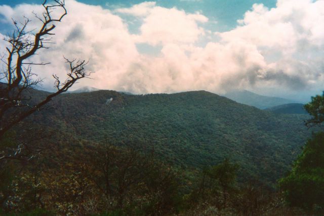
Orderville Rappel, Zion Ponderosa Ranch, Utah

Though technically this was a rappel and not a hike (the hiking part lasted only a short time -- about a mile or less), I'm putting this in my hiking journal because I feel the need to memorialize the fact that I actually did it. Outside of the practice rappel down the side of the Zion Ranch activity barn, this was my first real rappelling experience, and it scared the wits outta me.

Jay and Cindy and I hopped in a suburban with Amber and Staci from East Zion Adventures, and drove out to a 150-foot dropoff on ranch property. The road to get there (the same one we used when we did the Orderville Canyon hike on July 6) was a rocky, steep, dry riverbed that required four- wheel drive and a lot of machismo to navigate. It was enough to nearly shake my breakfast loose. Luckily I had very little breakfast in me, because I had trouble eating anything that morning, I was so worked up about rappelling. The terrain we drove on was so choppy I'm surprised we didn't blow a couple tires.

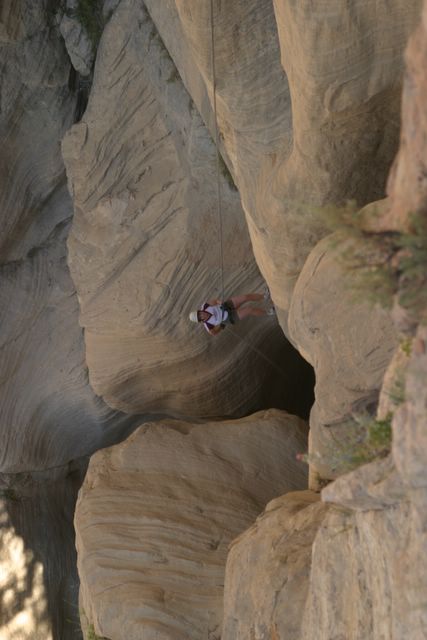
We parked the suburban about 9:15, loaded up some backpacks with our equipment, and hiked about 15 minutes out to our cliff. Each of us rappelled down twice. Staci stayed at the top to check our harnesses, and Amber belayed at the bottom. The first time was down a lumpy, steep rock face. My arms felt so shakey I was worried that I might not be able to trust my right arm to hold myself up.

My left arm was none too steady, either, as it was busy feeding rope through a flimsy-looking little piece of metal that climbers and rappellers (a very witty bunch) have cleverly dubbed an "air traffic controller." Hard to appreciate the humor in the name when you're watching that thing, bug-eyed, wondering if it's going to give way and send you smashing into the side of the cliff.

But everything went fine and I felt pretty empowered at having made it to the bottom of the cliff in one piece. When I finally landed, I realized that I had been gripping the rope so tightly with my left hand that I could barely pry my fingers open. My hand ached for several minutes and felt like it might fall right off my arm.

For the second rappel we switched the ropes over to a "keyhole," a deep crevass in the side of the cliff, and rappelled down the inside of it. At first I didn't think I would do the second rappel, because my hand hurt so badly the first time, but everyone else talked me into it and down I went. Peer pressure is an amazing thing. I'm really glad I did it, though; it was so cool to be inside of that crevass, looking up, looking down, and really enjoying the experience rather than just breathing through the terror (which is all I did the first time). My left hand was fine, but I had to keep reminding myself to loosen my grip.

High point: Conquering my fear of rappelling. I feel pretty comfortable with this now and would actually do it again. Would even be interested in something higher or more challenging. (Did I actually say that?)

08 July 2004


This is the fin of rock they call Angel's Landing. It's enormous. We climbed right up the spine of this bad boy.

Afraid of Heights? No problem, just don't look down.

Trek to top of Angel's Landing, Zion National Park, Utah. Five miles, ~4 hours including breaks and lunch.

I had no idea how challenging this hike would be! It is dubbed the "most strenuous" frontcountry hike in Zion National Park, but who knew it would require climbing straight up for two and a half hours?! Cindy and I hiked together, leading the way (Cindy claimed a "pancake advantage" due to the lavish breakfast at Zion Ranch just before leaving for the park.) Janet and Jay brought up the rear. We started about 10 a.m. and got done at 2 p.m. (yes, doing this hike during the sunniest, hottest part of the day was not the best decision).

The first mile or so went okay, with a steep but manageable grade. Then we got to this interesting area called Walter's Wiggles, which got steeper and more difficult. Then we got to the last half-mile of the climb, where the park has installed metal chains to hang onto at some of the more dangerous spots, so you don't go skittering down the rock face to your death. (A Boy Scout died that way just two weeks earlier, and he fell so far it took two days to recover his body. Really.) It was probably the most difficult hiking I've done. The height bothered me a bit, and I couldn't discipline my mind enough to quit thinking of falling. At some points, the steep, rocky path was only a foot or two wide, with steep dropoffs on both sides. But it was worth it to get to the top, which was 1,500 feet above the place where we started, and the view there was spectacular.

Quote of the day (from Janet): "I'd hike Orderville Canyone three times before I'd do this again!"

We dragged our sweaty, bad selves into Springdale after our descent and enjoyed ice cream and cold pop.

06 July 2004


Cindy, Janet, Daniel, and Jay in Orderville Canyon

Conquering Orderville Canyon

~12 miles, starting at Zion Ponderosa Ranch and winding through to the Virgin River in Zion National Park, Utah. Took ~7 hours including breaks and lunch.

Hiked Orderville Canyon trail with Jay, Cindy, Janet, and a guy named Daniel, who saved our hides. We started out on ranch property, hiked a steep switchback trail down to the canyon, and hiked a dry riverbed for about five or six miles. A trickle of water appeared eventually (spring-fed I think?) and turned into a small river about half the width of Mill Creek. We hiked the remaining six or seven miles through sixty-degree (read: cold) water, sometimes an inch or two deep, sometimes over our heads (!). It was very difficult to navigate over some of the steep boulders, particularly a couple of chokestones which have created dropoffs measuring about fifteen feet. There were a few areas where we had to use webbing to navigate our way down. Our first exporsure to "technical" hiking! It was a bit scary but pretty exhilarating.

In three or four spots we needed to climb or slide down huge boulders into deep water and swim across the deep parts until we could regain our footing. One time I plunged all the way under, after jumping from the two boulders between which I was (very daintily) wedged. We all got thoroughly soaked, as did our packs. Thanks to Daniel's swimming skills, Jay's camera actually survived with only a scrape or two -- no water damage. We were all amazed about that.

Daniel is part of the family who owns Zion Ponderosa. He had hiked this trail nine times already, so he pretty much knew what we were in for around every turn. At the hard parts (like areas that required submersion in water!) he went first so we could see the best way to negotiate the terrain. He also caught us a couple times when the climb down a boulder was especially hard. Without him it would've been, at worst, impossible, and at best, emotionally draining and nerve-rattling, to complete this hike.

Next time I would wear boots intead of my New Balance trail shoes.

High points: Seeing Cindy conquer some of her fear of deep water. Admiring God's artistry and immenseness in the huge rock sculptures, slot canyons, and boulders.

Low point: Slipping on a submerged rock and hammering my right knee pretty hard, at about mile 10. I was getting tired and sloppy.