09 June 2007

A.T. Hike, Spring 2007 - Day 6,
In Which I Said Goodbye to the Trail Till Next Time

Hogback Ridge Shelter to Sams Gap

Well, after six days on the trail, I and everything I’m wearing smell like Buster after he’s rolled around in the grass on a rainy day. It’s pretty disgusting.

Since today’s hike was short and sweet with very few big vistas, I snapped several pictures of the flowers that decorate the mountains. Spring is such an amazing time to be in this part of the country. I have always been an abysmal gardener, but that doesn't stop me from appreciating the wild beauty of flowers like these.

This one has the unfortunate name of spider wort, which in my mind detracts quite a bit from its splendor. I think it deserves a much daintier name, don’t you?

This is my favorite: mountain laurel. These grow on trees and their blooms drop to the ground in early June; in fact, many trees this week had already lost all their flowers, and some parts of the trail were covered in white because of it. It felt wrong to walk on something so exquisite. The blooms are so lovely and delicate, they look like they belong on a wedding cake. Even the underside of each flower is intricate and perfect.

Here’s something called a flame azalea, also known as rhododendron. They come in other colors too, but the orange ones were really plentiful this week. In some spots, these bushes surround the trail on the left and right, with their branches having grown together about 10 feet above you, forming a sort of tunnel to walk through.

This one’s a firepink. Aren’t those petals cool? I love their shape.

I’m a little embarrassed to say that when I finally neared Sams Gap, where the A.T. intersects with a paved interstate at a trailhead parking area, I actually let out a primitive little whoop when I saw my car. I don’t think I’ve ever thought of that rusty little Altima as beautiful until today. I love the trail, but I also love leaving it after this many days. So I said goodbye to the A.T. till probably this fall.

As of today, I have 314.4 miles down, 1,855.6 to go!

A.T. Hike, Spring 2007 - Day 5,
In Which I Joined Some Hippies

Jerry Cabin Shelter to Hogback Ridge Shelter, 14.7 miles

The first order of business today was to summit a peak called Big Butt – now there’s a mountain I can really relate to! (Who names these things, anyway!?) At 4,750 feet, it’s the highest peak of this trip. On my way, I met a pretty sizeable turtle who was sunning himself in the middle of the trail. Here he is – unfortunately he was too shy to peek out and look at my camera.

Though it was fun getting to the top of the mountain, the real reward was in pressing on to a spring four miles past, where I was finally able to take in some much-needed water. At a shelter near the spring, I ran into four hippie types – thru-hikers who were just starting their day. As I stopped to chat with them and take a brief rest, two of them rolled their own cigarettes, another lit a stick of incense, and the fourth practiced yoga. (I am not making this up!) The whole scene reminded me of a humorous book I read recently in which a sort of uptight conservative guy finds himself “living in the woods with some beatniks” for a few months. Here I was, kind of doing the same thing, feeling all Bohemian-like and almost fitting in. I totally blew my cover, though, when the hippies happened to mention that we were in a spot with a great cell signal: I took out my phone to call Jay, and my inner Bohemian got immediately upstaged by my Midwestern Pollyanna self as I started chattering. “Hi Honey! How are the kids? How was Joe’s T-ball game? Did Maria do okay at 5th-grade camp? Have you been watering my flowers?” After I put my phone away it occurred to me I must’ve come across just like Florence Brady to these four earthy hikers. Ah well.

Turns out the hippies ended up at the same place as me tonight: Hogback Ridge Shelter. I’m glad to be with people tonight, after spending several evenings solo. Also at this shelter is an older couple named Bonnie and Phil. Being from Indiana, they bring the evening’s Midwestern Pollyanna count up to three, including me. They are in their seventies and are so adorable together. They have a very meticulous routine for cooking their dinner – they brought their own homemade backpacker food which they had dehydrated themselves, and I must admit, it looked a lot better than my reconstituted black bean soup. As I chatted with Bonnie after dinner about Michigan and my family, her eyes lit up and she asked, “You didn’t happen to write an article for the ATC last month did you?” I felt like such a celebrity! She had read the article just before beginning this trip. Even the hippies fussed over me for a few minutes.

Tomorrow will be my last day on the trail. I had intended to hike for seven days, but since my plans got all bungled due to the bear problems at Walnut Mountain, I’ll end up covering all my planned miles in six days rather than seven. I don’t mind admitting that my body is completely spent and I’m absolutely giddy about finishing early.

08 June 2007

A.T. Hike, Spring 2007 - Day 4,
In Which I Did a Poor Impression of a Billygoat

Spring Mountain Shelter to Jerry Cabin Shelter, 15.4 miles

There was a very persistent mouse in my shelter last night. At one point I was lying on my stomach, looking out the front of the shelter, and the little pest ran right in front of my face, close enough that I'm quite sure I felt fur brush the tip of my nose. Due to that unnerving episode, I slept with my Petzl in my hand all night and turned it on about nine hundred times in the night to shine him out whenever he got too close.

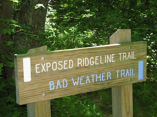
I thought today was going to be fairly easy because in the profile on my topo map, there’s a several-mile stretch of what looks like fairly level ground. “Level” being a relative term, of course – meaning that there are certainly ascents and descents, but none of them resulting in an altitude change of more than 500 feet. What the topo map doesn’t show is that the terrain for that stretch is really not a footpath at all – it’s a series of boulders perched high atop an exposed ridge - a ridge so high and exposed, in fact, that if there is any sign of bad weather, you're supposed to instead follow a blue-blazed trail that takes you to a lower elevation beneath the tree canopy so that you don't become a lightning rod. Since the weather was perfect today, I of course opted for the ridge, not realizing at first that instead of hiking, I'd find myself “scrambling” for about two and a half hours. This is hiker vernacular for half-crawling, half-climbing like a billygoat over boulders the size of cars, your hands and feet groping wildly for any secure crevice that might keep you from cartwheeling down the side of the ridge into either Tennessee (cartwheel left) or North Carolina (cartwheel right); the trail at this point is exactly on the state line. Contributing to the drama in my case was the swinging counterweight of a 30-pound pack flopping about on my back. I was white-knuckling it the whole way during this segment, and my progress slowed to about a mile an hour. I tried to focus on the spectacular view instead of my chances of snapping a bone. Here’s what I saw to my left and to my right as I scrambled:

Finally, a grueling nine net hiking hours after starting my day, I made it to the shelter. Like last night, there is a mouse here. He made an appearance while I was eating my dinner. My biggest concern, though, is not the mouse but rather the fact that the spring near this shelter is completely dry, and I had been counting on really tanking up my water supply when I got here. I am so very thirsty, but I need to carefully conserve my water for the first six miles of my day tomorrow - first thing in the morning I have a very big climb (you know, for a change).

07 June 2007

A.T. Hike, Spring 2007 - Day 3,
In Which I Ate a Bug

Deer Park Mountain Shelter to Spring Mountain Shelter, 14.2 miles

I descended from Deer Park Mountain about 6:30 this morning and was treated to some amazing views. I love being so high up on a very clear morning like this, and looking down at those swirling clouds gathered between the mountains! Click on the photo for a close-up. Believe it or not, under those clouds is an entire town (Hot Springs, NC), and to the people down there, it looked like a cloudy, gray day until the sun burned through a few hours later.

After the descent, I followed the trail through the main drag of Hot Springs, where the trail is marked on the city sidewalk by these cool inlaid symbols. Hot Springs might seem like just a sleepy little burg to the casual onlooker, but it’s definitely a storied locale for thru-hikers – they fantasize for miles about this place, because not only is it one of the few places in the eastern U.S. where you can experience natural hot mineral springs, but the town also features an outfitter, an ice cream shop, a pub, and several little places where you can rent a room and sleep in a real bed for the night. I didn’t stick around to explore, though, because I had hours of hiking ahead of me.

After you get through town, the trail takes you alongside the French Broad River (can you beat that name!?) and then attempts to inflict a slow and painful death via a steady, steep climb up to the top of Lovers Leap Rock. If that’s not enough to do you in, there’s more: a lung-burning trek to the top of Rich Mountain. It was during that particular ascent that I inhaled a bug. Saw it coming, felt it go in. Swallowed it. Didn’t care. It was a rather businesslike decision, really, to just suck it down the old hatch and keep moving. It’s just that I was so determinedly making upward progress on that mountain, and every step was so hard-earned; it seemed like far too much energy and distraction to stop and spit the thing out. I guess now that I’m a bug eater, I could qualify for being on “Survivor” – if I looked better in a bikini.

My lawnmower blister is healing nicely, but I’m worried about another one cooking on my toe - that abnormally long toe next to my big toe on my left foot. This morning I encased the entire digit in moleskin on all sides. It still hurts though, even now that I’m stopped for the night. I’m afraid to take the moleskin off to see what’s underneath. I think I’ll just leave it be and see how it feels in the morning.

I’m alone again tonight and much too tired to worry about bears.

06 June 2007

A.T. Hike, Spring 2007 - Day 2,
In Which I Met a Loon

Roaring Fork Shelter to Deer Park Mountain Shelter, 14.7 miles

After the storm rolled in yesterday afternoon, it rained in torrents till about midnight, but today turned out to be a beauty day. Here’s a neat photo, courtesy of a very industrious spider who must’ve gotten an early start on her web when the air was still very moist last night. Click on the picture to see a closer view.

Summited Walnut Mountain and then Bluff Mountain this morning. No small feat, either of them. It’s really a pity that with many of these mountains, the vegetation is so tall and thick that even after you make it to the top of a really challenging peak, the view is usually obstructed by all the trees surrounding you. The shot below was the best vista I could snap from the top of Bluff Mountain.

I met my first loon on the trail today, and I don’t mean the wildlife variety. I was just coming down from the peak of Bluff Mountain when I noticed another hiker approaching from the opposite direction. He looked normal enough from a distance – late fifties, kind of Paul-Newman-ish. Then I noticed that everything he was carrying – his pack, his sleeping pad, everything – was made completely of Tyvek. I also noticed that he was barefoot – yes, completely without shoes or socks. (Loon or not, you gotta admit that’s pretty impressive. There were no roads or towns around for at least five and a half miles, so you know he hiked at least that far over a rocky, root-ridden trail without a stitch on his feet.) He immediately came a little too close and said a little too loudly: “Who are you?” At which point I thought, this is it. This is the end of me. This nutjob is going to kill me and cut me into little pieces with a Swiss army knife and leave my body in the woods for the bears to eat.

It was the first time I’ve felt threatened by another person on the trail. But as it turned out, he wasn’t dangerous at all, just quirky. His hike is part of a publicity effort – he’s pushing for legislation that would require all troops to go through a counseling program upon returning to the States, I guess in an attempt to stave off post-traumatic stress disorder (see his website, http://www.thelongwalkhome.org/ ). Interesting and noble concept, but he sure could use some help with his marketing plan, and some congeniality lessons wouldn't hurt either. Not to mention the fact that the barefoot/Tyvek getup had me ready to throw off my backpack and start doing Tae Bo moves in an effort to protect myself. The photo above is from his website, which I looked up after I got home.

Here’s my home for the night: Deer Park Mountain Shelter. I’m alone here and only slightly worried about bears. I did find a decent tree in which to hang my food, but I’m afraid an enterprising bear could probably have it down and eaten in mere minutes.

05 June 2007

A.T. Hike, Spring 2007 - Day 1,
In Which I Saw Two Bears

Standing Bear Farm to Roaring Fork Shelter, 15.5 miles

My hiking has begun! It was a wicked-long day and I am toast.

I started out at 7 a.m. and about an hour into the climb up Snowbird Mountain, while walking along a switchback, I suddenly heard a lot of branches breaking and something big crashing around about 40 feet to my right. See, that’s the cool thing about bears –they’re a little scary, but at least you usually have some warning that they’re around because they’re big enough and clumsy enough that they make a lot of noise. Anyway, through the trees I saw this ball of black fur, maybe a 100-pounder, and I had apparently scared him because he made quick work of loping away from me. I watched him till I couldn’t see him any more; then I started to move on, thinking smugly, “How fun, I saw a bear my first day, and look at me – such a seasoned hiker that my heart’s not even racing.”

Then a second bear darted right in front of me, maybe 30 feet ahead, and bumbled his way up the mountain. That’s when I nearly fell over backward and my heart rate doubled. See, both bears were juveniles, which meant their mother was probably close by, and here I was, between her two darlings. Probably not the safest place to be. I quickened my pace and was all nerved up for about an hour, until I had gotten well out of whatever feeding territory of theirs I had apparently invaded.


I noticed lots of evidence of wild hogs on the trail today. There are many areas where hundreds and hundreds of Mayapples (these grow in Michigan too and look like the one in this photo) have been rooted up and scattered about, and many upturned areas of soil where the hogs have looked for truffles. I’m guessing the weather has caused a food shortage for them as well as for the bears.


Below is a view from the summit of Max Patch, which was one of the coolest sights today – I’d heard a lot about it. It’s a bald, about 4,600 ft. in elevation, and it used to be the site of an old logging camp. It’s very pretty at the top but a storm was collecting in the distance so I didn’t linger too long there. The rain started about 4 p.m. so the last half-mile of my hike was wet.

At tonight’s shelter I met two young guys who are thru-hiking at the rate of 25 miles per day (hot doggers!) and they offered to hang my food bag with theirs, to which I readily agreed. Chivalry does come in handy at times.

No blisters yet, unless you count the one on my thumb which, actually, I brought with me. I produced it while pushing the lawn mower on the day before I left. Now that’s an outdoorswoman for you – I get a blister while lawnmowing. It broke open and had started to heal by the time I hit the trail. Today it resembles a small piece of prosciutto.

I drank more than six liters of water today.

04 June 2007

A.T. Hike, Spring 2007 - Day 0,
In Which I Scrap My Carefully Planned Itinerary

I’m at Standing Bear Farm, the hiker hostel just off the A.T. (same place where Cindy and I stayed for a night last year) and will get on the trail early tomorrow morning. The Steve Miller Band and I enjoyed a great drive down to Tennessee; James Taylor and Norah Jones joined in for about a hundred miles too. Thank goodness for the iPod or else I’d most certainly go catatonic being cooped up in the car by myself for so long.

Unfortunately, I found out from a few other hikers here at the hostel that in the last couple days there’s been a lot of aggressive bear activity at Walnut Mountain Shelter, which is (rather, was) my destination two nights from now. Apparently the other night a bear absconded with eleven hikers’ food bags. He also played piƱata with what he thought was one giant food bag – but which was actually a hiker sleeping in a hammock just outside the shelter. Oy. I’m told the bears are very hungry right now because, due to a late cold snap and a recent drought, a lot of the berries they rely on for food did not produce very well this spring.

Anyway, hikers are being advised to stay away from that shelter for now, especially when hiking alone. This presents a problem for me, because skipping that shelter means more than doubling my planned mileage tomorrow. I had kind of looked forward to easing into my hike with a nice easy 7.5- mile day. Now it looks like it will be 15.5 miles. Crud.